Posted on Aug 31, 2017 in
FEATURES
 Hurricane Season begins June 1st annually, and continues to November 30th each year. In Fort Bend County, hurricane damage occurs from a combination of high winds, inland flooding and tornadoes.
High winds from 74 mph to over 200 mph can easily topple power lines, uproot trees and knock down buildings as far as 175 miles from coastal areas. If Hurricane Rita had come ashore anywhere from Matagorda Bay to Galveston Bay, Fort Bend County would have surely seen damage from high winds.
Flooding caused by torrential rains is probably the greatest threat that storms pose to inland counties such as Fort Bend. Hurricane Claudette (1979) dumped 45 inches of rain near Alvin, Texas and Tropical Storm Allison dumped 36 inches of rain over parts of Harris County in 2001.
Tornadoes are often spawned by hurricanes and can occur well away from the center of a storm. In 2004, Hurricane Francis spawned a record 123 tornadoes.
Evacuation Information
Mandatory Evacuation Zones are established based on the threat of flooding due to storm surge. Since Fort Bend County is not at risk for storm surge, the County will not be part of the mandatory evacuation of coastal communities.
Fort Bend County has been designated by the State of Texas as a “Pass-Through” County. This means that coastal communities who are designated as “Evacuation” counties will pass through Fort Bend County along designated evacuation routes to designated “Shelter” counties. The designated evacuation routes through Fort Bend County are State Highway 6 and State Highway 36.
Should I Evacuate?
Unless there is a threat so great to Fort Bend County that damage from the hurricane will be strong enough to cause major damage to the majority of structures in the County, Fort Bend County will only order a voluntary evacuation, meaning if you want to leave, you should do so.
A voluntary evacuation should be considered mandatory if the following conditions are present:
- You live in an area that has a history of flooding.
- You live in a structure that is unable to withstand winds of greater than 75 miles per hour, such as a manufactured housing or housing that is significantly older.
- You are unable to be without electricity for an extended period of time.
If I Decide to Evacuate, Where Should I Go?
It is understood that the majority of Texans will choose to evacuate to hotels or relatives outside of the areas at risk. However, for those who have nowhere to go, the State of Texas has developed a State Evacuation and Sheltering plan where individuals who evacuate can stay in shelters at designated communities who have developed plans to shelter large populations in a shelter hub system. Evacuees will enter the host county and will then register at a Reception Center and then be assigned to a specific shelter in the community that will meet their needs.
If you do not feel safe in your home, Fort Bend County Office of Emergency Management (OEM) strongly encourages you to leave and evacuate to one of the shelter hub communities. There are plans in place to open shelters of last resort in Fort Bend County, mainly for individuals stranded on the evacuation routes. These shelters of last resort will not be announced until approximately 10 hours prior to expected tropical storm-force winds affecting the county. All persons who are utilizing a shelter of last resort are expected to bring their own food, water, blanket and cots, since these shelters are for weathering the storm only. There are no guarantees that these shelters will be open in the County, so we again encourage you to evacuate if you require a safe place to weather the storm.
What if I Have Functional Access Needs?
Special needs people include those who are disabled, ill or on a low income with no transportation – anyone who needs assistance if they are to evacuate. Even though Fort Bend County is not within a mandatory evacuation zone, residents are still eligible for evacuation transportation assistance. Emergency Management Departments are collecting information on those who will need assistance evacuating. Please register your information with 2-1-1 so we know who you are.
What if I Have a Pet?
 The state recognizes that many evacuees will arrive at shelters with their pets. Host communities have been directed by the State to make accommodations for these pets. This, however, does not mean that your pet will be allowed to be with you in the shelter. The only pets that will be universally accepted at shelters will be service animals such as guide dogs, dogs that assist the hearing impaired or dogs for wheelchair-bound persons. Some shelters may be able to provide space for pets in covered, exterior corridors or in an adjacent support building where pets on leashes and in carriers will be temporarily housed. In the case that the shelters are unable to accommodate pets, owners may also be referred to local kennels or animal shelters. A list of shelters will be found at reception centers in host communities. Larger animals (horses, cattle, etc.) or exotic pets (snakes, spiders, etc.) will most likely be housed in an alternative location than the shelter, at fairgrounds or similar accommodations. Pet owners are encouraged to bring their own leashes and crates, feeding dishes, food and medications. Owners also should provide immunization records and tags for their animals.
If I Decide to Evacuate, What Should I Expect?
Because of the sheer numbers of people and vehicles that need to leave at-risk areas, you can expect a long, slow process of getting everyone out. Even before Hurricane Rita, planners estimated that it would take approximately 30 hours to get people out of the storm-surge risk areas in Galveston and Brazoria Counties. The timeline is expectedly longer depending on how far inland persons are traveling. Although changes have been made, such as ensuring that gas stations have completely full fuel tanks in the entire region before a storm hits, as well as fuel and resources being made available along the evacuation routes, evacuees can still expect a long, hot trip. Make sure that you have plenty of food, water for both your family and your pets.
Visit www.fbcoem.org/hurricanes/ for more information.
Hurricane Categories and Wind Speed Information
Hurricanes are rated according to the Saffir-Simpson Scale (from 1-5) based mainly on wind speed and storm surge.
Wind damage is negligible. Main dangers stem from flooding that can accompany slower moving storms. In 2001, Tropical Storm Allison was responsible for 41 deaths, nationwide and caused the largest urban flood on record (until Hurricane Katrina).
Category 1 Hurricane
74-95 mph
Minimal damage to building structures. Damage mainly occurs to unanchored mobile homes, shrubbery and trees. In 1989 Hurricane Jerry struck Texas and caused over $70 million in damage.
Category 2 Hurricane
96-110 mph
Moderate damage to roofing material, doors and windows. Considerable damage occurs to vegetation and mobile homes. Hurricane Frances (2004) was a Category 2 hurricane.
Category 3 Hurricane
111-130 mph
Extensive damage to small residences, utility buildings and other smaller structures with a minor amount of facade failures. Mobile homes are destroyed. Large structures are damaged by floating debris. Hurricanes Rita and Katrina were both rated as Category 3 storms.
Category 4 Hurricane
131-155 mph
Extreme damage including more extensive wall failures and some complete roof structure failures on small residences. The “1900 Galveston Hurricane,” which covered Galveston Island with a 15-foot storm surge and killed 8,000 people, was a Category 4 hurricane.
Category 5 Hurricane
155 (+) mph
Damage is catastrophic including complete roof failure on many residences and industrial buildings. Some complete building failures with small utility buildings blown over and away. In 1969 Hurricane Camille came ashore with wind speeds estimated at 190 mph and caused complete devastation to many parts of Louisiana. During the 2006 Hurricane Season, record 4 hurricanes (Dennis, Katrina, Rita, and Wilma) all reached Category 5 strength (but luckily downgraded) before coming ashore.
What Should I Take With Me?
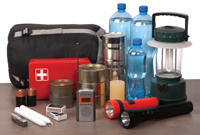 License or identification card with photo
- Medications, extra eye glasses, hearing aids and other essential items
- A flashlights with batteries
- A battery-operated portable radio, if you don’t have a car radio
- Water or other beverages to drink on your trip
- Non-perishable foods to eat on your trip
- Spare clothes and shoes
- Soap, shampoo and other toiletries
- Important papers, including deeds and wills
- Contact numbers of friends, family members, physicians and your insurance agent
- Money, checks, travelers’ checks or credit cards
- An inventory of your personal belongings and any photographs or videotapes of your possessions

 <
<